Monday afternoon: Evacuation mandatory for some, encouraged for all
'Forget Irene. It's nothing compared to what's coming our way'
City officials are still advising people in flood-prone areas of the city to evacuate as soon as possible, as buses heading to county evacuation centers will stop running at 5 p.m.
A hurricane flood map of the city can be found here. This map is not a prediction based on Hurricane Sandy, but shows which areas are subject to potential flooding from storm surges during two types of hurricanes. The mandatory evacuation applies to areas near the lakes; between Ocean and Grand avenues; and the Springwood corridor.
Anyone who needs shelter should report to the Thurgood Marshall Elementary School at for processing. Buses will then transport them to county shelters. City OEM chairs Terry Reidy and Kevin Keddy said winds should get closer to 50 miles per hour later today, rendering bus travel too dangerous. “If you don’t get there by 5, your chances of getting transferred to a shelter by us is going to be slim or nonexistent,” Reidy said.
Asbury Park schools are closed today and tomorrow, Tuesday, district communications officer Chrissy Coloma said today.
Residents who choose to stay behind are advised to stay inside, and especially to stay away from downed power lines and trees. Travel throughout the city will likely be impossible as the storm strengthens.
Six are without power in Asbury Park according to this interactive map from FirstEnergy. Keddy and Reidy anticipate major outages as the storm intensifies.
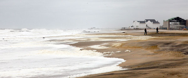
The storm’s flooding is largely subject to tides. At high tide this morning around 8 a.m., the ocean overflowed past the dunes and into the unpave parking lot at the North Beach, Keddy said. Parts of the ocean reached boardwalk bulkheads this morning as well. The tide has slightly receded as low tide is coming around 2 p.m., but waters will peak again for another high tide around 8 p.m. tonight.
Officials insist the storm will be much more significant than last year’s Hurricane Irene.
“Forget Irene,” Reidy said. “It’s nothing compared to what’s coming our way. They’re saying it’s going to be worse than the ’92 storm, so … no one alive has experienced this kind of storm.”
The storm is still slated to hit ground in Atlantic City around midnight or 2 p.m., but it’s about 1500 miles wide, so the impact in Asbury Park will still be significant, Reidy said.
“Based on our flood mapping, there’s a possibility that 40 to 50 percent of Asbury Park could experience flooding,” Keddy said.
Hurricane Sandy has been moving northward through the Atlantic Ocean and is expected to hit land somewhere on the Jersey Shore just before midnight National Weather Service meteorologist Mark DeLisi said yesterday.
The storm’s pattern “differs from every storm that I can ever remember, in that it’s going to be moving up the coast off the coast and then suddenly start to get pulled inland,” DeLisi said in a phone interview from the NWS’s Mount Holly headquarters. “Storms usually move north or northeast and the farther north they go, the more northeast.”
It’s better to be on the west side of a storm like Hurricane Sandy, DeLisi said, but since the storm is being dragged westward, some portion of the Jersey coast will “take a direct hit.”
Before the storm makes ground on Monday night, conditions will have already deteriorated “to quite possibly a dangerous place,” DeLisi said.
To keep abreast of developments in the city, Keddy said residents can check the Asbury Park Fire Department’s Twitter account, the city website, and the local news media.
Keddy urges city residents to register for the Code Red system, which can be done by clicking here. The system notifies residents of emergency situations.
Follow the Asbury Park Sun on Twitter and Facebook to stay updated. Send hurricane photos and news tips to news@asburyparksun.com.
———-
[Photo by PAUL SHAPPIRIO]


